DKI Jakarta Province serves as the capital of the Republic of Indonesia, which has a specificity duties, rights, obligations and specific responsibilities in governance and as the locus of representatives of foreign countries, as well as centers / representatives of international agencies. This province has an area of 661.52 km² land and 6977.5 km² the ocean with a population of 8,525,109 inhabitants in 2010 that make this area as one of the densely populated area in Indonesia. Jakarta located on the northwest coast of Java Island, at the mouth of the Ciliwung River, Jakarta Bay. Jakarta is located in the lowlands with average height of 8 feet above sea level and 40% of Jakarta areas, particularly the northern areas, are below the sea level, while the southern parts are comparatively hilly. Rivers flow from the Puncak highlands to the south of the city, across the city northwards towards the Java Sea; the most important [clarification needed] is the Ciliwung River, which divides the city into the western and eastern principalities. Other rivers include the Pesanggrahan, and Sunter.
These rivers, combined with Jakarta's low topography make it prone to flooding from swollen rivers in the wet season and high sea tides. Other contributing factors include clogged sewage pipes and waterways that service an increasing population, in addition to deforestation near rapidly urbanizing Bogor and Depok in Jakarta's hinterland. Furthermore, Jakarta is an urban area with complex socio-economic problems that indirectly contribute to triggering a flood event.
DKI Jakarta Province is divided into 5 administrative regions and one city regency, namely:
· Administrative city, Central Jakarta with 47,90 km2 area
· North Jakarta, with 142,20 km2 area
· West Jakarta, with 126,15 km2 area
· South Jakarta, with 145,73 km2 area
· Administrative city, East Jakarta, with 187,73 km2 area
· Regency, Seribu archipelago, with 11,81 km2 area
In the north of Jakarta, the beach stretches along 35 km that become as estuary for 13 rivers and 2 channels. In south and east, Jakarta was adjacent to Depok city, Bogor, Bekasi city and Bekasi district. In west was adjacent to Tangerang city and Tangerang district, and on the north adjacent to the Java Sea.
Geologically, the whole plain of Pleistocene sediments contained in the ± 50 m below ground surface. The southern part consists of alluvial layer, while low-lying coastal stretches to the inland about 10 km, underneath there are layers of older sediments that are not visible on the surface of the soil due entirely buried by alluvium sedimentation. In the northern region, solid soil exist at a depth of 10-25 m and in the southern region, solid soil exist at a depth of 8-15 m. In certain parts there are also solid soil layer with a depth of 40 m.
Jakarta is generally hot climate with maximum temperatures ranging from 32.7 ° C - 34, ° C at noon, and minimum air temperature ranges from 23.8 ° C -25.4 ° C at night.
The average rainfall is 237.96 mm throughout the year, during the period 2002-2006 the lowest rainfall of 122.0 mm occurred in 2002 and a height of 267.4 mm occurred in 2005, with humidity levels reaching 73.0 - 78.0 percent and the average wind speed reaches 2.2 m / sec - 2.5 m / sec.
Problems
There are 3 major problems in DKI Jakarta, they are:
· Flood
Flood in Jakarta is a classic problem. This problem triggered by the geographical location of Jakarta, located in the lowlands coupled with a relatively high rainfall is 350 millimeters during the rainy season (January-February). Besides that, poor drainage problems and mass of garbage in sewers and rivers also become the reason why Jakarta area is often flooded. It could be argued that Jakarta is flooded almost every year, and some flood events claimed casualties. Heavy floods in Jakarta occurred in 1996, 2002 and the most experienced losses in 2007 which was recorded within 10 days at least 80 people listed die because of dragged by current, electric shock, or illness. Floods lead to interruption of business operations at all, consequently the business community suffered material losses up to 4.3 trillion rupiah. Until February 7, 2007, residents who fled reach 320000 people. The main cause of these floods is heavy rainfall, and duration of the rainy season in Indonesia that occurred which began in December and ends in March. In 2007, rainfall intensity reached its peak in February, with the greatest intensity at the end of the month. Nearly 60% of Jakarta area inundated with depths reaching up to 5 meters in some point (http://id.wikipedia.org/wiki/Banjir_Jakarta_2007). In subsequent years, Jakarta is still experiencing flooding (although not as bad as previous years).
Recorded on January 14, 2009, DKI Jakarta re-experiencing flooding. According to data TMC Polda Metro Jaya (Jakarta metropolitan area police), on Wednesday (01/14/2009), there are inundations due to rain in 5 areas in Jakarta. For North Jakarta, areas that were flooded are Pol Polker Post, Bintang Mas with inundation height of 50 cm. Teluk Gong road, Kapuk Raya, in front of PT Bimoli, with inundation height of 30 cm. Muara Baru, Perintis Kemerdekaan street, Kramat Jaya, Sunter, Kodamar, with inundation height of 20 cm. While in West Jakarta, inundation struck Latumenten Street with height of 20 cm, Arjuna Street with height of 10 cm and Karang Tengah Street with height of 5 cm. South Jakarta areas also got inundation. In Pos Pol Pancoran, inundation height of 15 cm, in front of Lenteng Agung station hall with height of 10 cm, around Semanggi Bridge and Sudirman Street with height of 8 cm, and in Pancasila University with height of 5 cm. Some area in East Jakarta also inundated. The inundation area occurs in front of Duren Sawit hospital and Cakung police station, with inundation height of 20 cm. In front of East Jakarta mayor office and Taman Modern with inundation height of 30 cm and in Bukit Duri with inundation height of 50 cm. For Central Jakarta, inundations reach Pangeran Jayakarta Street with height of 20 cm and Cempaka Putih Street with height of 15 cm.
On June 8, 2009, flooding occurred again in Jakarta. In South Jakarta flooded areas are Gelael and in front of Atma Jaya campus with a height of 30 cm respectively. At Balai Kartini with a height of 20 cm. in Central Jakarta area, inundation occurs in front of Sarinah with height of 30 cm, Manggala Wanabhakti with height of 20 cm and in front of Germany embassy with inundation height of 15 cm. In East Jakarta area, inundation occurs in Matraman Raya Street with height of 30 cm and in Kebun Nanas with inundation height of 20 cm. As while for West Jakarta, inundation area was in Ibis hotel with height of 30 cm.
Flooding occurred again on October 3, 2010 and flooded Bangka Raya Street with inundation height of 50 cm, Pondok Karya Police dormitory and Pondok Jaya Street with height of 20-30 cm, for West Jakarta, there is one inundation point, in front of Citra Land with inundation height of 20 cm.
On October 9, 2010, floods inundate Jakarta again, specifically Cipinang Melayu administrative village, Makasar District, East Jakarta. Inundation water height causes by this flood is 50 cm and resulted 500 houses flooded.
· Rob
Rob is a phenomenon when sea water entered the hinterland. This is causes by the sea level higher than that hinterland. DKI Jakarta with its geographic condition that has a low land makes this area often flooded by rob. Many of Embankments that built so far are still made from sand bags that can easily be penetrated by sea water. Besides that, some of permanent infrastructure is not in a good condition. There are proven by embankments burst so that sea water could easily flood the hinterland.
The inundation of hinterland area due to rob fairly common happened in North Jakarta. Recorded in November 2007, Penjaringan administrative village, North Jakarta was flooded as height as 30-40 cm. On May 8, 2008 due to the high tide causes the levee break along 60 m in Pantai Mutiara Pluit Houses, Muara Baru and Pluit administrative villages were flooded as height as 50 cm. On the same date, Rob also inundating 26th-27th km toll access to Soekarno-Hatta Airport with height of 1 meter. It makes the traffic flow closed to and from the airport.
On June 2, 2008, Rob inundating the northern part of Jakarta again, including Muara Baru as height as 30-50 cm, Penjaringan as height as 25 cm, Pasar Ikan as height as 15-20 cm and Kanal Muara as height as 10-15 cm. Rob also occurred on November 16, 2008 and flooded the Muara Baru as height as 30 cm, this is caused by embankments that made from sandbags was broken.
Rob also inundates North Jakarta on May 12, 2009 due to Pluit embankment broken along 60 meters. The flooded area were Penjaringan RT 15 RW 7 with a height of 60 cm, Kamal Muara RT 6-9 RW 1 with a height of 10-15 cm, Pejagalan (Teluk Gong Raya) with a height of 10-15 cm, Kapok Muara RW 1 with height of 5-15 cm, Vikamas RW 5 with a height of 5-20 cm, Kapok Raya RW 3 with a height of 10-35 cm, SMP 22 with a height of 30-40 cm, Kapok Muara administrative village with a height of 45 cm, North Pluit with a height of 20 cm and Mutiara Beach RW 16 with a height of 20-60 cm.
Marunda area re-flooded due to rob on November 5, 2009 with inundation height of 60-80 cm. As a result, 500 houses submerged and 20 hectares of fishponds be lost. On the same day Kamal administrative village, West Jakarta was flooded due to rob as height as 30-50 cm, as the result Kamal Raya roads flooded and disturb traffic flow.
On December 2, 2009 rob occurred again. Muara Baru area, RE Martadinata Street and Bintang Mas area inundated up to 20 cm, this inundation causes traffic on RE Martadinata Street.
On December 4, 2009, RE Martadinata Street, New Road Ancol, Muara Baru and Pasar Ikan area flooded with an inundation of 30-40 cm height. As a result of this rob, RE Martadinata re-experiencing traffic jam.
Muara Baru and RE Martadinata Street exposed to rob with a height of 50 cm on the 6th December 2009. This inundation filled the street to 400 m from the front BMW garden to Tanjung Priok. Related to this problem, one of Jakarta Provincial Government's efforts to overcome this problem is building rob embankments along 3.5 kilometers. But new construction is completed approximately 800 meters due to budget shortfalls. Another relief efforts try to do is to install water pumps in the floodgate near Hailai, Ancol.
Rob Floods also inundate RE Martadinata Street on January 2, 2010 with a height of 20 cm.
Subsequently on June 15, 2010, rob inundating RE Martadinata Street and Jalan Baru Ancol, North Jakarta as height as 40-60 cm, this condition leads to a traffic jam. Inundation of water extends to the WTC Mangga Dua as height as 15-20 cm. Due to rob, two-wheel riders forced to spin direction and find another alternative road. These conditions create a crowded situation of traffic flow at RE Martadinata Street and Jalan Baru Ancol.
On June 25, 2010, rob floods inundating the area of Muara Baru, North Jakarta with a height of 50 cm. This happens due to a buffer in sea dikes in the region collapsed.
The last rob occurred on 3 October 2010 which flooded the region of Kamal Muara. This is caused by the tidal water-retaining embankments not in a good condition and some of public behavior that pierce embankments.
· Land Subsidence
Subsidence occurring in DKI Jakarta is the effect of population growth in this area. Concomitant increase in the number of residents in Jakarta, also growing sectors of life in this area, includes: industry, education, health services, offices etc. This of course makes Jakarta filled by large buildings that eventually makes the soil in this area has decreased each year.
The main causes of subsidence in the Jakarta area are:
Ø Extensive conversion of prime agricultural areas into residential and industrial areas
Ø Significant disturbance to main ecological function of the upland of Jakarta area as a water recharge area for Jakarta city
Ø Increase in groundwater extraction due to development of industrial activities and the high population increase
Observed subsidence rates in Jakarta, the rates vary both spatially and temporally can be seen in the Table 1 below.
Table 1 Observed subsidence rates in Jakarta; the rates vary both spatially and temporally
No
|
Method
|
Subsidence Rates (cm/year)
|
Period
|
1
|
Leveling surveys
|
0-9
|
1982–1997
|
0-25
|
1991-1997
| ||
2
|
GPS surveys
|
0-25
|
1997-2008
|
3
|
InSAR
|
0-12
|
2006-2007
|
Source: Hasanuddin Z. ABIDIN, Heri ANDREAS, Irwan GUMILAR and Mohammad GAMAL, Indonesia, Yoichi FUKUDA and T. DEGUCHI, Japan. Land Subsidence and Urban Development in Jakarta (Indonesia)
Problem Impact and Losses
· Flood
Health, Social and Political Impact
The impact caused by flooding in the health sector is causing various diseases such as diarrhea, upper respiratory infections (URI), skin diseases, and so forth. In the end the various diseases that arise as a result of this flooding, re-create new problems in form of costs for treatment and revenue lost because inhabitant can’t go working.
In the social sector, flooding resulted in affected areas communities become a second class society. They are considered to be those who can’t afford to buy homes in flood-free area, which is now become a higher price.
In the political field, the occurrences of floods almost every year result in reduced public confidence in government who are considered unable to anticipate and resolve this flood problem.
Economic Impact
The most widespread impact is in economic sector. First, the flooding caused most economic activity stalled. For example in 2007, due to flooding that inundated about 60% of Jakarta Floods lead to interruption of business operations at all, consequently the business community suffered material losses up to 4.3 trillion rupiah.
If the manufactory ceased to operate, meaning workers who usually work and earn wages become unemployed and lost revenue. Employers also suffer losses, because they can’t produce and acquiring revenue. Next, consumers are also disadvantaged due to reduced supply of goods that would normally be followed by rising prices of the goods.
Second, damage to various buildings, factory equipment, and various economic infrastructure. Damage to buildings and equipment are clearly detrimental to the owner. While damage to economic infrastructure such as roads, bridges and market also result detrimental to the common people, beside the stakeholder.
Third, decline in value of land and buildings in areas affected by flooding. It is also highly detrimental to the owner, whereas the land and buildings are often used as a tool for a safe investment. If it is not affected by flooding, then land prices will always rise. But due to flooding, land as a safe investment tool no longer to be valid.
Fourth, flooding causing local government revenue decrease and expenditure increases. Local government revenues declined because of taxes and levies are also decreased, along with a decline in economic activity due to flooding.
In addition, the Land and Building Tax (PBB) that is not dependent on the ups and downs of economic activity also will go down. Because, as already mentioned, the flood caused a decrease in the value of land and buildings. If the value of land and buildings decrease, then revenue from the Land and Building Tax (PBB) will be down.
· Rob
Health, Social and Political Impact
The impact caused by rob has similarities with the effects caused by the floods. In the health sector for example, due to rob inundation will cause various diseases such as diarrhea, upper respiratory infections (URI), skin diseases, and so forth. The perceived economic implications are the same, due to illness is required for treatment and additional costs due to illness also reduce revenue because inhabitant can’t go working.
In the social field, rob usually flooded the second class society areas. Gap between the rich and the poor become more real. In addition, due to inundation water that reached the highway, become other social problems, because making a bad traffic jams in Jakarta.
In the political field, as well as the impact caused by the floods, the trust of society declined against the government.
Economic Impact
Similarly, the floods caused by rains, the economic impact caused by rob was a problem that is wide enough. When areas of economic activity inundated, then the economic activity automatically will be disrupted and even totally stop for a while. Stakeholders will suffer large losses.
· Land Subsidence
One of subsidence impacts is damage the existing buildings in Jakarta, for example RE Martadinata Street vanish on September 16, 2010. This road vanishes as deep as 7 meters and width of 100 m. It is possible if other protocols roads are going through the same thing. Another impact is the reduction of ground water reserves. The decline of land in Jakarta is the result of taking excessive reserves of water in this area. The rapid industrial development requires a greater supply of water, thus forcing the owner of industry to take back the ground water in this city. Decreasing in ground water reserves is certainly a big problem for the city as it relates to various aspects of life both in terms of health, social and economic. Lack of clean water reserves will lead to various skin diseases, diarrhea, etc. In the social field, clean water can be enjoyed easily by people who have a greater income while those who are not able will have trouble to get it. In economic field, the existence of rare clean water will cause the price of water increases.
In addition, other impact caused by subsidence is flood area widespread. Due to land subsidence in Jakarta, Low areas will widen and flooding will be very easy to hit Jakarta (if the flood is not yet implemented).
Affected Area
· Flood
Based on flood maps issued by the Jakarta metropolitan area police, flood-prone locations in the province of DKI Jakarta there are 82 point spread in 5 municipalities as found in Figure 1 below.
Figure 1 Map of Jakarta Flood Prone Areas
In North Jakarta, flood-prone locations are: Podomoro Street, Plumpang Street, Perintis Kemerdekaan Street, Kapuk Muara Street, Cakung Priok, Kelapa Gading, Teluk Gong, Yos Sudarso Street, Justus, Jaya Motor, Sunter Jaya RT 06/09, Pegangsaan, Hybrida Street, Cilincing.
In the Central Jakarta includes Cepu 13 area, Gambir, Caralus-Matraman, Tanah Abang Jati Baru station hall, Dukuh Bawah, Gunung Sahari, Latuharhary Street, Biak Street, Sarinah, Kampung Bencong, Rawasari, Letjen Suprapto, Petojo Selatan, Roxy, Petamburan, Caringin Street.
In East Jakarta covering DI Panjaitan Street, Kampung Melayu, Terowongan Mina, Otista Raya Street, Cawang Underpass, Cipinang Melayu, Carolus Hospital until Matraman, Swadaya Duren Sawit Street, in front of Duren Sawit Hospital, Bidara Cina, Perintis Kemerdekaan, Colonel Sugiono Street, Jatinegara Barat, Kebon Pala Halim Street, Pinang Ranti Street.
In South Jakarta includes Teluk Bangka, Cileduk BNI highway, KOSTRAD Tanah Kusir, in front of Pertanian Petrol Station, Kalibata-Dewisartika, in front of Four Season Hotel, in front of Tarakanita, Kemang Bawah, Abdul Majid, Kemang Puri Sakti, Gatot Subroto Street, Kemang Selatan, Pesanggrahan, Jeruk Purut Street, Blok O, Pondok Indah highway, Pondok Karya POLRI complex, Antasari Street, Pinang Timur 2, Kemang Utara, Kalibata Jembul.
And in West Jakarta covering Daan Mogot Street, Puri Kembangan, in front of the Mayor office of West Jakarta, Citraland, Kebun Jeruk, in front of SAMSAT Barat, Rawa Buaya, Latumenteng Empang, Asirot Sukabumi Selatan Street, Puri Kembangan, S Parman Street, KY Tapa Street and Pos Pengumben.
· Rob
Area experiencing robs in Jakarta, generally occur in North Jakarta, because this area directly facing the sea and has a low soil surface. In Figure 2 below can be seen satellite map of rob prone in DKI Jakarta.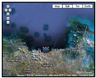
Figure 2 Satellite Map ROB Prone Areas in Jakarta
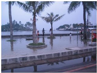
Figure 3 Rob inundate Ancol Recreation Area

Figure 4 Rob flooded the parking area in Ancol
Figure 3 and Figure 4 above shows the incidence of rob on November 24, 2010 in Ancol area. High water level can’t dam by embankments, this resulted in the entry of sea water to this region easily.
· Land Subsidence
Areas that experiencing subsidence in DKI Jakarta can be seen through Figure 5 below.
Figure 5 Map of subsidence area in DKI Jakarta
Handling Efforts
· Flood
Handling of flooding in the area of Jakarta that has been done is to build a flood channel. There are 2 flood canals in this city, the west flood channel and east flood channel (which had just completed). Besides that, sporadic dredging also did in the rivers that crossing Jakarta city, but this effort not functioning optimally. For the future planned a program to dredging 13 rivers that cross the Jakarta city, the program is known as the Jakarta Emergency Dredging Initiative (JEDI). But the program still can’t be implemented because it is still hampered by legal problems.
Other handling for flooding problems that have been done is to use the polders system (temporary water reservoirs where the water in this polder can be directly pumped into the sea). Currently, Jakarta has 33 polders and planned to add 15 polders. Jakarta's largest polder was located in Pluit Reservoir area. In this polder operating system, used 83 units of water pump in large reservoirs and 96 units in small reservoirs. In addition there are underpass pump 46 units and 83 units of mobile pumps. Mobile pump is a pump that can be driven to suck the water that flooded an area. From the total number of mobile pumps, as many as 41 units on standby to be used at any time, and 42 units have been placed at several points in five areas of Jakarta.
The flooding problem in Jakarta, one of which resulted from reduced basin's natural ability to absorb rain water into the soil (infiltration) due to the construction of evolving so rapidly. To overcome this water runoff, infiltration wells need to be made at certain points in the drainage channel itself. Whether drainages along the highway or in residential areas. Most important of all ascertained rainwater can flow into the nearby drainage channel. Water entering into the well recharge in drainage volume would reduce the burden of river water.
· Rob
Some of rob handling in Jakarta is still a temporary treatment. As rob on May 12, 2009, the government makes temporary repairs to the embankment that burst its banks by building sandbags plaster and tarpaulins. This handling of course does not last long, for it required a permanent confectionary. Currently the government is building embankment along the 3.5 kilometers (But construction is still 800 meters were completed due to lack of budget) and government also installing water pumps at the water gate near Hailai, Ancol in early December 2009.
· Land Subsidence
Until now there has been no specific response to the problem of subsidence in the Jakarta area.
Data Source:
8. http://www.bangadang.com/berita/potret-jakarta/1847-pasang-rob-terjang-wilayah-kamal-jakarta-barat
9. http://arsipberita.com/show/publik/2009/12/02/muara-baru-dan-jl-re-martadinata-tergenang-rob.html
13. http://news.okezone.com/read/2010/01/02/338/290254/338/air-rob-jalan-re-martadinata-tergenang-20cm
22. http://borin.wordpress.com/2010/10/09/banjir-jakarta-2010-500-rumah-di-cipinang-melayu-terendam/
23. Hasanuddin Z. ABIDIN, Heri ANDREAS, Irwan GUMILAR and Mohammad GAMAL, Indonesia, Yoichi FUKUDA and T. DEGUCHI, Japan. Land Subsidence and Urban Development in Jakarta (Indonesia)
4 comments:
related to land subsidence, maybe you may looking for the other research of GPS survey by Mr. Hasanuddin and friends.
anyway,good article, very interesting..
Thanks for ur comment,, and thanks for ur info...
There are plans to save Jakarta.
One of them is to stop using the groundwater, that is why Jakarta is sinking (subsidence), in return free water is being supplied. Jakarta floats on its groundwater. And the flood water from the rain needs to be pumped into the ground.
Or to pomp sea water into the groundwater, but this means that the groundwater can't be used for the next 20 years.
Many is already being done by the Indonesian Government.
We the Dutch has also a plan to solve the over populating of Jakarta and to stop the flood from coming in.
http://www.dutchwatersector.com/news-events/news/8608-new-garuda-shaped-master-plan-gives-jakarta-new-perspective-on-coastal-city-development.html
http://floodlist.com/asia/plans-reduce-jakarta-flooding
There is so much more to be found on the web also in Behasa Indonesia.
So your blog could use some serious up-dat.
Goodluck.
Albert
Thx Albert for your comments. Yes, I notice about that plans. I hope someday I can write a good article about it. also thanks for your references.
Regards
Destry M S
Post a Comment